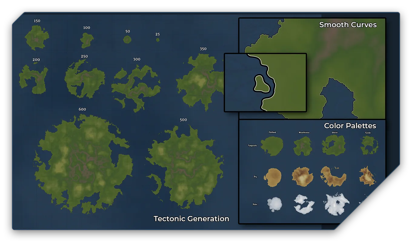
NEWS

MAPPING IT OUT July

This month's update is mainly a status update, showing where the current development stands, what we're working on and what the current progress is. As part of the update we showed a preview of the new Tectonics II system and our first steps into the river tool. 


Tectonics II Prototype

Smooth Curves

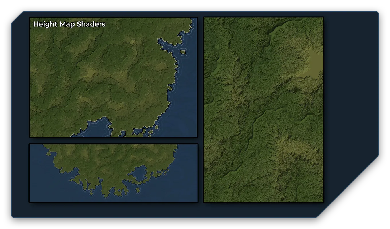
The first big improvement is the addition of more realistic coastlines. Previously our coastlines were created with hard edges, which we were not happy with in the first place. While they worked good enough on high altitude zooms, they always looked too generated when you zoom in and work on the details of a landmass.

Realistic Coastline Shapes

But more importantly, coastlines lacked the right level of realism, when created. We have now added a much more refined method to generate realistic looking coastline shapes, based on real world samples. We have achieved this, by combining libraries for geological processes like tectonic movement and erosion, and models for real world coastline shapes based on height maps. The result is that when you generate a landmass in future, the coastline is not just drawn by a random jitter, but derives from the height map that was created to simulate that landmass body.

Color Palettes

Our second goal is to use this to create an automatic colouring based on the height of a region and a selection of different climates like "Tropical", "Dry", "Temperate", "Continental", and "Polar".

The idea behind the system is that you can define the geological prerequisite of each landmass generated and they would be coloured in a way to already suggest where mountain ranges and the like could go, making it easier for you to add in those assets and - once we introduce the new reworked assets - have those blend in more naturally with the map as well.

Outlook

In the future, those areas could even be populated with assets automatically via the use of our Biome features. Before we can introduce that autofilling feature, we do want to make sure that we have a climate model in the system as well. As that would further dictate what kind of assets would fit in that biome.


Using shaders and erosion models to create a different map style


To better understand how our height maps might work we internally added light shaders and other filters to the map generation. The result was surprisingly pleasing since we can now also generate maps that follow a different artistic style and resemble a satellite view of the world beneath. 

However, we found that while it would still make sense to add assets like town markers and roads to those maps, adding other terrain assets would create a clash between the assets and this specific map style. This is why we have decided to shelf this new artistic style for the moment and return to it later, when we have mastered the original artstyle in the first place. We do want to keep both approaches as we do like how that map style looks, but we do not want to get lost in too many different concepts at the same time.


Finishing up the new tectonics tool

Now that we have a working prototype for the new tectonics, we need to improve the performance of the system and build a proper user-interface. We do hope to have a released and stable version for users to test out by the end of September.


Rivers Prototype

The Rivers tool is currently very much just a tech demo, there is no art to the system yet and it's mostly just programming and a proof of concept. Our main goal was to create a tool that is easy to use and allows river forks and river deltas that can be edited and adjusted any time. Based on standard path models, the river system is composed of different points that will also determine curves and bends of the river and river joints. Again, this is just a tech demo as of yet and the tool needs much more work before it can be published. Therefore any details in the tool are still subject to change.

During our testing phase we discovered that it might make more sense to split our “Rivers and Roads” into two separate tools as both look very different in real life and should therefore be handled differently and we want to avoid meshing up too many options into one single tool.


Next Mapping it Out

Due to scheduling conflicts and several vacations coming up throughout August, there won't be a Mapping it Out stream at the end of August and the next show is currently planned for September 27th. Make sure to follow us on our Social Media channels and Discord for further announcements regarding updates, news, and streaming schedule!

 
Presented by the Circle Of Worldbuilders


Have more questions?

Be part of our community
Get feedback and support from our wonderful Discord community!
Ask question about Mapmaking, Tooling and and get valuable Tips and Tricks.

ALPHA v0.4 AVAILABLE NOW

In order to access the Alpha you must have backed or preordered the project.
You can still preorder by clicking the login-button below.


Note to all Kickstarter Backers:
To activate your account for the first time, please use the activation link you have received via email.
If you haven't received an activation link, please contact us at contact@dungeonfog.com.